World Factbook GeoDatabase
Cross-national data for GIS and database applications
For more info or to purchase, click here to access form.
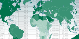
The World Factbook Geodatabase delivers the data from the well-respected CIA World Factbook in a format that can be directly incorporated into a GIS system. Data is in an Esri file geodatabase and a comma-delimited text file is included if you would like to import that data into a different database.
Cartographers and reseachers in the fields of geography, political science, economics, and others will find this product highly useful in creating thematic maps from the World Factbook's wealth of cross-national data.
Major features:
- Conversion of CIA World Factbook quantitative data into ESRI File Geodatabase format and comma delimited text file.
- Data consists of 187 data fields in addition to rank order fields. Dates and notes are preserved.
- Country geometry corresponding to Factbook entities
- Layer files and sample maps simplify Factbook-based thematic mapping
- Updated to May 2016
System requirements
- GIS software capable of reading Esri File Geodatabase format or database software capable of reading a comma delimited text file. Note that you will be able to open the comma delimited text file in Excel, but Access can only handle 255 fields and the Factbook database has more.
- Windows system to run self-extracting .exe installation files. This need not be the computer running the GIS system, but must be able to write data to a location accessible by the GIS system.
All other technical specifications can be found in the following PDF document: